
The Huascaran National Park is located in the Department of Ancash in north-central Peruvian Andes Mountains, and it was established in 1975 to protect 1,312 sq. miles for three main reasons. a) Conserve the biological diversity and natural resources, including rare and endangered flora and fauna species. b) Protect and maintain the landscape character. c) Protect glacier runoff that constitutes the main water source for hydropower generation, irrigation, and domestic consumption of central Peruvian region (1). The national park was declared a Biosphere Reserve in 1977 and a World Natural Heritage Site in 1985 by UNESCO (2).

Mount Huascarán is the highest peak in Peru, and in all of the Earth's tropics. The snowcapped peak rises to 22,205 feet (6,768 m) above sea level. It is the most popular mountain in Peru and is a favorite of mountaineers and tourists. Huascaran gives it's name to Huascaran National Park which surrounds it.

There are 74 families living within the national park, with a total population of about 349. Outside the national park, an additional 250,000 inhabitants living within the buffer zone at the Callejon de Huaylas, where mostly agricultural and urban development occur. Grazing, plantation forestry (nonnative Eucalyptus and Pines) and mining also happen. Being a long narrow area with several penetrating glacial valleys, the park is particularly vulnerable to entry from surrounding communities combined with the extensive Peruvian mountain road system, provide relatively easy access for hikers, climbers, and the livestock of traditional cattle herders. The valleys are grazed by both domestic and native livestock (llama and alpaca) (11). Increased pasture burning, hunting, overgrazing of alpine and subalpine pastures, and the reduction of Polylepis sp forests have been increased soil erosion, watercourse siltation and reduction of flora and fauna habitats (10). Also, other threats arise from global warming that specifically threatens its glaciers, uncertain land titles and park boundaries, government policies supportive of resource extraction within the national park, a major highway along the western side of the buffer zone, increase in tourism, and the continued demands of economic development for mining, roads, water power and resorts associated with hot springs in the buffer zone or with the mountain environment. Currently, there are four roads that cross the park from east to west. Even so, there is a continual threat of new road construction, which is being pushed by mining interests and by municipal governments (11).

Chavin Culture
The Cordillera region has human evidence (mandible and teeth) at the Guitarrero Cave in Yungay that has been carbon dated to 10,610 BCE. Ethnic groups have settled, as a proof by ruins at Kotosh in Chuchumpunta, Willcahuain in Huyllap-Pumacayan, and Hechkap in Jonkapampa. The Chavin civilization flourished between 900 and 200 BCE in the Callejon de Conchucos, spreading over northern and central Andes and it was one the earliest pre-Inca first major culture (12).

Precipitation in the zone originates primarily from very humid Amazonian air masses, although Pacific air movements have influence as well. As air masses move over the mountains, they lose moisture during ascend and eventually descend on the Pacific-side slopes. As a result, the Pacific-side climate is predominantly cold and dry. The Peruvian coastal desert’s atmospheric stability influence the lack of moisture on the park’s western slope. On the contrary, the huge air masses originating from Amazonian evaporation on the eastern slope contain a large amount of moisture that condenses and solidifies as the air ascends the mountains and falls as snow over Cordillera Blanca. The mean annual temperature is about 3°C, the minimum being -30°C. Mean annual precipitation is approximately 884 mm. (recorded at 3,980 m), falling mainly between October and May. Minimum temperature are found at the highest altitude and the maximum temperature at the lowest altitude (6).The park contains most of the Cordillera Blanca, the highest range of the Peruvian Andes and the highest tropical mountain range in the world, and the glaciers are the major part of its hydrology. Glaciers are distributed along 112 miles, from Mount Tuco in the south to close Mount Champara in the south. The Cordillera Blanca holds 27 peaks with altitudes surpassing 18,700 ft. and more than 200 are found around 16,400 ft. altitude, the highest is the Mount Huascaran that ranging from 8,202 ft. to 22,204 ft. at its summit (7). There are 296 lakes and the water from the Huascaran National Park forms 41 rivers that discharge into the Santa, Pativilca and Maranon river watersheds (Maranon River and Ucayali River confluence to form the Amazon River)(8).

The park has a rugged terrain that it is flanked from the east by Callejon de Conchucos Valley to the west by Callejon de Huaylas Valley (3). The landscape is a mix of intermedia and high altitude with severely eroded terraces that are steeply sloped (25 to 50 %) (1). The geological formation date from the Upper Jurassic to recent Quaternary periods are made up of sedimentary, volcanic, and base rocks the Andean batholiths severely folded and faulted by a combination of Andean tectonics at the end of the Cretaceous period and movements of the earth crust (5). The soils formed from alluvial, glacial, residual material, and anthropogenic forces. There are soils for use as pasture and forestry, however the extreme climatic condition limited it. Soil erosion is active in the protected area because natural forces (glacial retreat, climate change) and anthropogenic ones (overgrazing, deforestation, agriculture in inappropriate zones) (4).

Polylepis Incana
Ten mammal species have been recorded, including spectacled bear (Tremarctos ornatus), pampas cat (Oncifelis colocolo), Andean cat (Orailurus jacobita), Peruvian guemal or Andean deer (Hippocamelus antisensis), incan cougar (Puma concolor incarum), white-tailed deer (Odocoileus virginianus), northern vizcacha (Lagidium peruanum), and the vicuna (Vicugna vicugna) are important indigenous species, but all have been heavily hunted in the past. Some of the most notable bird species of the 112 that have been recorded include Gurney's buzzard Buteo poecilochrous, Andean condor (Vultur gryphus), giant hummingbird (Patagona gigas peruviana), giant coot (Fulica gigantean), torrent duke (Merganetta armata), and Puna tinamou (Tinamotis pentlanlii) (11).

Vicuna animals have the finest wool in the world
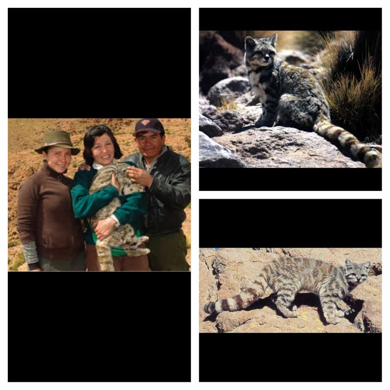
This is the Andean cat which is native to the Andes Mountains. This is an endangered species to the Huascaran National Park. This cat is pretty large compared to the average size of a pet cat.

Spectacled Bear or Andean Bear

Andean Deer or Taruca

Vizcacha


Andean Deer or Taruca

Vizcacha

Rapid melting of Andean glaciers in recent decades (Kaser) poses a threat to local water resources (14). There is also concern about glacier-related hazards such as glacier lake outburst floods. It is quite possible that the glacier retreat in the last three decades in the Cordillera Blanca may be a cumulative result of negative mass balance over prolonged periods, related to warm dry phases of ENSO (El Nino Southern Oscillation) This continued retreat suggests that the small glaciers of the Cordillera Blanca have not yet adjusted to the warmer temperatures since the 1970s, and are still in disequilibrium with the present-day climate (13). Combined geospatial analysis techniques with remote-sensing and field data to document spatial patterns of glacier changes in the Peruvian Cordillera Blanca from 1970 to 2003. This is the first comprehensive geospatial glacier inventory for the Cordillera Blanca since 1970. We summarize as follows: a) Glaciers of the Cordillera Blanca lost 22.4% of their area from 1970 to 2003, with no significant difference between glaciers on the eastern and western side of the divide; b) Small low-lying glaciers, with a large proportion of their area in the ablation zone, lost ice at higher rates than larger glaciers; c) Debris-covered glaciers lost a smaller proportion of their area than clean glaciers; d) There is a notable shift in glacier ice to higher elevations, with more pronounced shifts on the eastern side of the cordillera; e) Mean temperature increases over the past three decades have been greater at lower elevations than at higher elevations, with little change in precipitation (14).
The most effective way of handling threats and difficulties in Huascaran National Park is to follow the Master Plan that government created in 1989, but the insufficient budget and inefficient bureaucracy that works in the city leave the Plan forgotten. The small staff of 26 workers (14 park rangers, 6 technical staff) and several laborers have did a terrific job to protect the huge park. The park needs to restore the native Polylepis and Puya Raimondi forests, and to design mechanisms to manage native grasslands. Prohibited burning and vegetation removal, and illegal hunting. Coordination with the communities around the park to protect it because they will be the major beneficiaries. Remove gradually nonnative livestock for Lamas and Alpacas. Tourism have to be more sustainable and responsible to avoid threat of the biodiversity. Mining impacts on the soil, rivers, lakes, and other of water must be diminished. Even though, mining rights were granted before the park was declared, any mining activity occurring within the park should be discourage. New dam and hydro power projects within protected area should be limited and the current in operation have to be strictly supervised. Glacier recession is unavoidable because is a global problem, but during the months of higher precipitation, from October to March, the glacier could be closed to visitors to enable to grow.
Table 1. Loss of glacial surface
area in five South American countries
Country: Area in km² (year) Area in km² (2006)
Peru 1,958 (1970) 1,370
Bolivia 562 (1975) 393
Ecuador 113 (1976) 79
Colombia 109 (1950) 76
Venezuela 3 (1950) 2
Total 2,744 1,920
Francou, B., E. Ramırez, B. Caceres
and J. Mendoza. 2007. Glacier evolution in the Tropical Andes during the last
decades of the 20th century: Venezuela, Colombia, Ecuador, Peru and Bolivia.
Ambio, 29 (7), 416–422.
Table 2. Glacier elevation and area
changes from 1970 (IGN
digital inventory) to 2003
(SPOT-derived glacier outlines) for the
367
selected glaciers in spatial domain 2
Number
of Area change Median Z
Terminus Z
glaciers change change
% m m
Eastern CB 135
–21.9 +69.4 +136.76
Western CB 232
–22.2 +63.2 +99.4
All glaciers 367 –22.1 +65.6 +113.4
Kaser, G., A. Ames and M. Zamora.
1990. Glacier fluctuations and climate in the Cordillera Blanca, Peru. Ann. Glaciol., 14, 136–140.
The most effective way of handling threats and difficulties in Huascaran National Park is to follow the Master Plan that government created in 1989, but the insufficient budget and inefficient bureaucracy that works in the city leave the Plan forgotten. The small staff of 26 workers (14 park rangers, 6 technical staff) and several laborers have did a terrific job to protect the huge park. The park needs to restore the native Polylepis and Puya Raimondi forests, and to design mechanisms to manage native grasslands. Prohibited burning and vegetation removal, and illegal hunting. Coordination with the communities around the park to protect it because they will be the major beneficiaries. Remove gradually nonnative livestock for Lamas and Alpacas. Tourism have to be more sustainable and responsible to avoid threat of the biodiversity. Mining impacts on the soil, rivers, lakes, and other of water must be diminished. Even though, mining rights were granted before the park was declared, any mining activity occurring within the park should be discourage. New dam and hydro power projects within protected area should be limited and the current in operation have to be strictly supervised. Glacier recession is unavoidable because is a global problem, but during the months of higher precipitation, from October to March, the glacier could be closed to visitors to enable to grow.
Work Cited
(13)Ames, A. 1989. Glacier inventory of Peru, Part 1. Huaraz, Peru, Hidrandina S.A
(11)Bartle, J. (1993). Parque Nacional Huascaran, Ancash, Peru. Asociacion de Ecologia y
Conservacion, Lima, Peru.
(5)Dawna L. Cerney. (2010) The Use of Repeat Photography in Contemporary Geomorphic Studies: An Evolving Approach to Understanding Landscape Change. Geography Compass 4. Web 22 Nov. 2015. http://onlinelibrary.wiley.com/doi/10.1111/j.1749-8198.2010.00376.x/abstract;jsessionid=C2B2A420DA8DE39A4CBF3D0BDA3DBB7E.f04t02
(4)Egeler, C. and De Booy, T. (1956). Geology and Petrology of the Southern Cordillera Blanca, Peru. Netherlands. ISBN: B0007JNUG0
(10)G. Hoch, C. Korner. (2005) Growth, demography and carbon relations of Polylepis trees at the world's highest treeline. Functional Ecology 19:10.1111/fec.2005.19.issue-6, 941-951. Web. 22 Nov. 2015. http://onlinelibrary.wiley.com/doi/10.1111/j.1365-2435.2005.01040.x/abstract
(6)Johnson, A.M. 1976. The climate of Peru, Bolivia and Ecuador. In Schwerdtfeger, W.,ed. World survey of climatology. Amsterdam, etc., Elsevier, 147–218
(14)Kaser, G., A. Ames and M. Zamora. 1990. Glacier fluctuations and climate in the Cordillera Blanca, Peru. Ann. Glaciol., 14, 136–140
(7)Kinzl, H. and Schneider, E. (1950). Cordillera Blanca. Innsbruck, Austria. 168pp
(1) Ministerio de Agricultura (1974). Informe tecnico para establecer los limites provisionales
del Parque Nacional Huascaran. Zona Agraria III. Mimeo. Huaraz.
(3) Parque Nacional Huascaran http://www.sernanp.gob.pe/sernanp/zonaturismoi.jsp?ID=16
(12)Silvia Rodriguez Kembel, Herbert Haas. (2015) Radiocarbon Dates from the Monumental Architecture at Chavín de Huántar, Perú. Journal of Archaeological Method and Theory 22, 345-427. Web. 23 Nov. 2015.http://link.springer.com/article/10.1007%2Fs10816-013-9180-9
(8)W Buyttaert, R Celleri, B Debievre, F Cisneros, G Wyseure, J Deckers, R Hofstede. (2006) Human impact on the hydrology of the Andean páramos. Earth-Science Reviews 79, 53-72.
(9)Weberbauer (1945). El Mundo Vegetal de los Andes Peruanos. Ministry of Agriculture, Lima. 766pp.